
 |
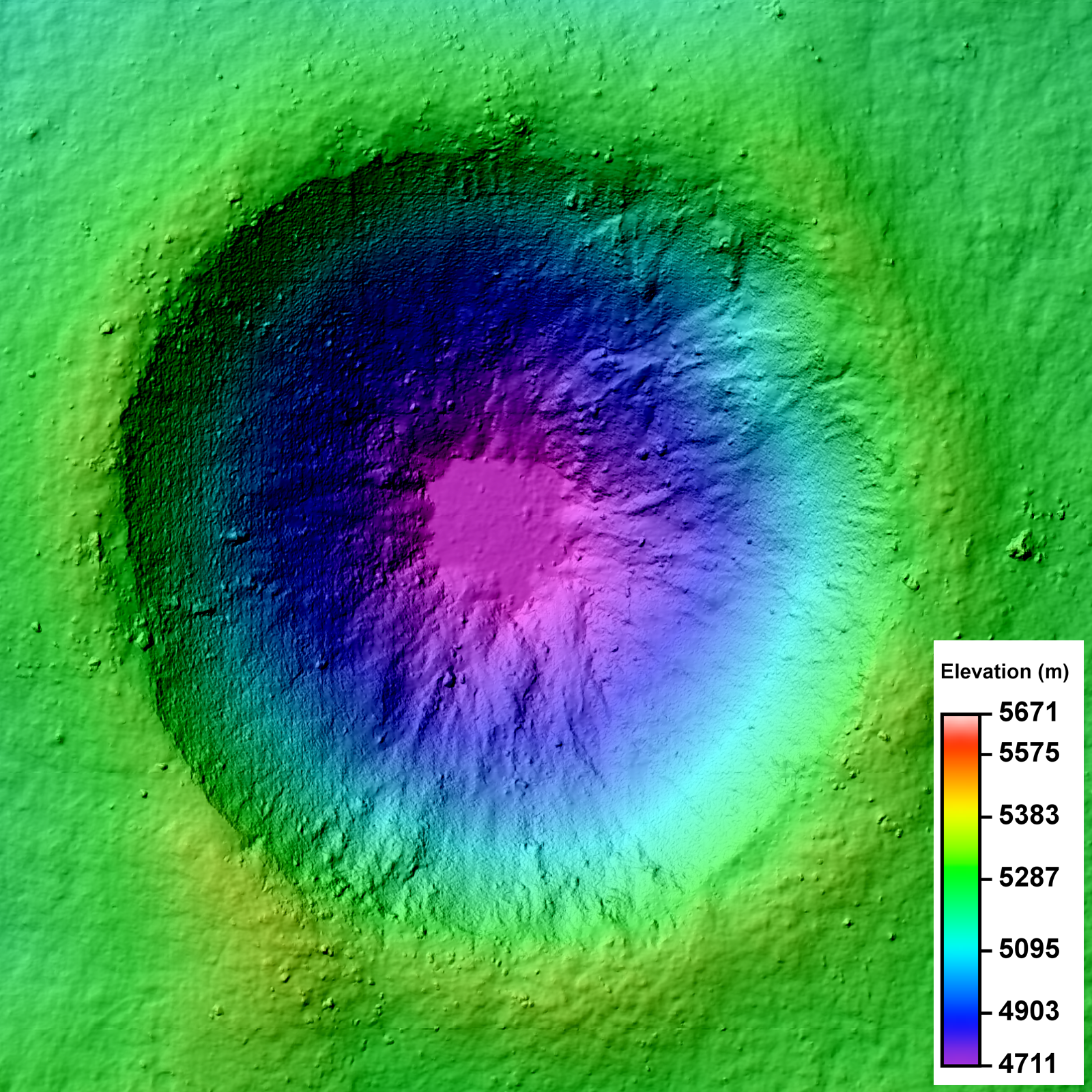
| LROC Narrow Angle Camera (NAC) Digital Terrain Model (DTM) of an unnamed crater in the farside lunar highlands. Image field of view 3.2 km across. See the much larger (1600px) LROC Featured Image HERE [NASA/GSFC/Arizona State University]. |

LROC News System
LROC Featured Images show off the incredible variety of stunning lunar geology imaged by the LROC NACs. While these beautiful images allow scientists to study the surface of the Moon with respect to morphologic detail and albedo variations at 0.5 meters per pixel, repeat - or stereo - images of the same location on the surface at similar illuminations but different viewing geometries provide scientists the chance to create a 3D topographic model. Why all the fuss? Well, these Digital Terrain Models, or DTMs, are critical to scientific investigations where topographic information about the lunar surface aids is necessary. Today's Featured Image is a DTM of a 2.3 km diameter unnamed impact crater (17.682°S, 144.408°E) west of Isaev crater. This impact crater is very young, evidenced by its high-reflectance ejecta blanket, and is of scientific interest because the interior crater morphology is complex (see image below).
 |
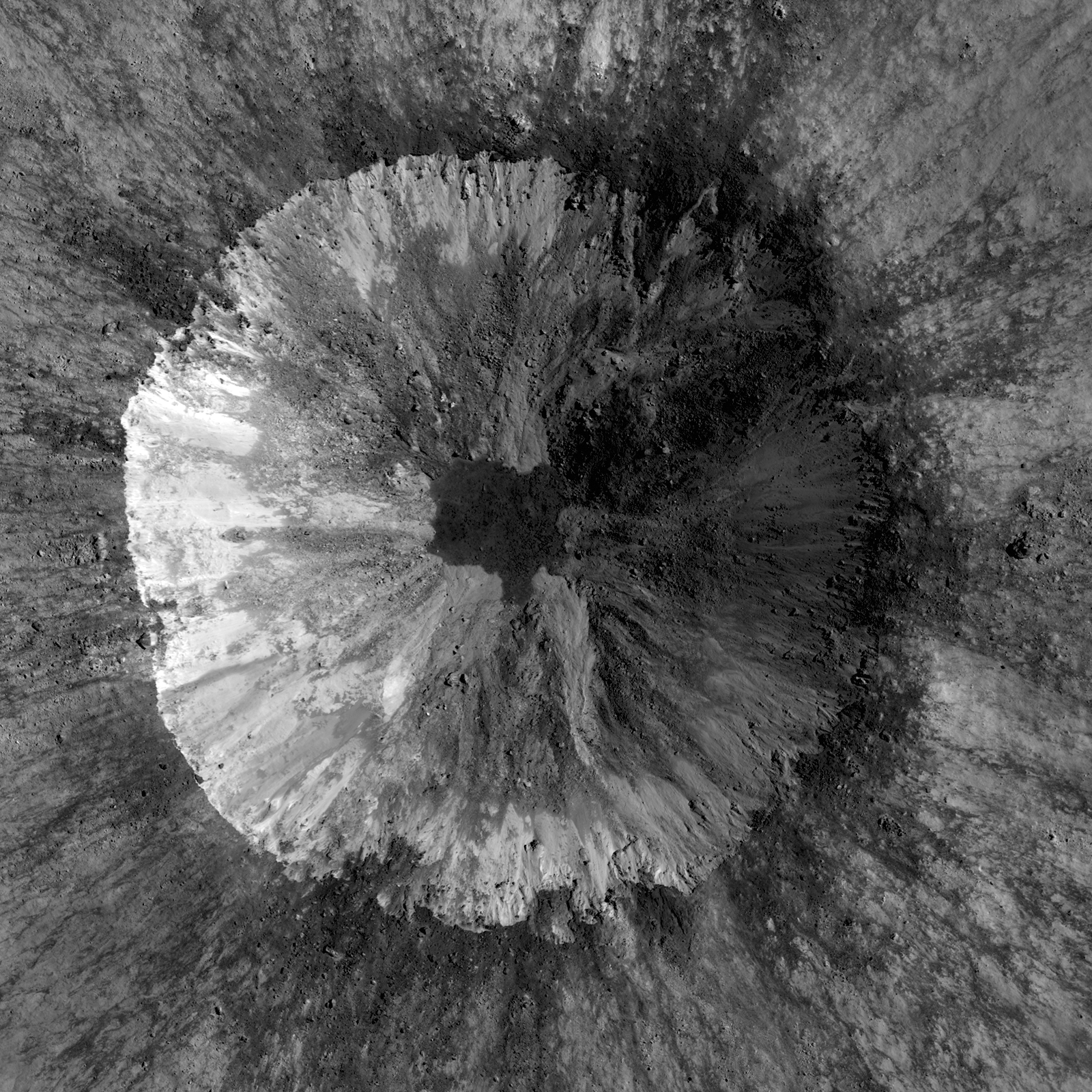
| LROC Narrow Angle Camera (NAC) mosaic of an unnamed 2.3 km diameter crater, one of the two NAC stereo pairs used to create the DTM represented in the LROC Featured Image released May 2, 2012. While your brain knows the crater is concave, a depression, because of illumination and shadowing, the NAC mosaic alone can't be used to determine the elevation change from rim to floor. Image from LROC the left and right coincident frames of LROC NAC observation M143683729, resampled to 2 meters per pixel resolution for the DTM, field of view is 3.2 km across. LRO orbit 6308, November 6, 2010; from 61 kilometers. View the larger LROC complementary image HERE [NASA/GSFC/Arizona State University]. |
 |
| Full resolution (62.58 meters per pixel) detail from LROC Wide Angle Camera (WAC) observation M176690527C (604nm) shows the subject crater under mid-afternoon illumination (incidence 64.28°), LRO orbit 11174, November 23, 2011 from 48.8 kilometers. When comparing with the LROC QuickMap 6 x 6km topography at lower right we can see the 400 meter rise in elevation, from the crater floor to the selected area's terminus just to the northeast, witnessing how the complexity of terrain's elevation is not easily visible from overhead [NASA/GSFC/Arizona State University] |
 |
| Simulated oblique view west from 150 kilometers over the LROC Wide Angle Camera (WAC) monochrome 100 meter Global Mosaic spread upon LOLA altimetry (ILIADS Application, Lunar Mapping and Modeling Project). The Copernican Age crater highlighted in the LROC Featured Image released May 2, 2012 is the small crater with a bright ejecta blanket at bottom center. in the farside highlands - 450 kilometers east of the central peaks of mare-filled Tsiolkovskiy crater, visible at top center [NASA/GSFC/LMMP/Arizona State University]. |
DTMs derived from LROC NAC stereo images are extremely useful because DTMs provide quantitative measures to complement qualitative descriptions. For the case of determining the smoothness of the impact melt pond, the slope of the crater walls and floor deposit can be calculated using the DTM. At the scale shown above, 2 m/pixel, the impact melt deposit surface is all at the same elevation and can thus be considered to be smooth. Furthermore, DTMs sometimes reveal unexpected observations! In the full frame of the LROC NAC DTM, there is a region of lower elevation to the north of the unnamed crater and a region of higher elevation to the south; these regions are not easily discerned in the LROC NAC mosaic.
Take a look at the full LROC mosaics - (DTM and NAC) - and see how the morphology you observe in the NAC image is linked with the elevation you see in the DTM.
Discover the Moon using DTMs in the DTM RDR Archive, HERE.
Direct link to today's Featured Image DTM in the RDR Archive.
Related Posts:
Barnstorming Linné crater
A Digital Terrain Model of the Orientale Basin
Precise 3D Measurements of Objects at Apollo 14Landing Site from LROC NAC Stereo Images
No comments:
Post a Comment